
The Project Focal Area: The California Central Valley
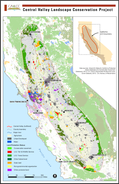 Map of the Central Valley Landscape Conservation Project Study Area, by Justin Epting. Click for a larger version. |
The Great Central Valley of California is a vast, flat valley approximately 450 miles long and averaging 50 miles wide at the geographic center of California. The Central Valley contains four subregions: the Sacramento Basin, the San Joaquin Basin, the Sacramento-San Joaquin River Delta, and the Tulare Basin. The Central Valley Landscape Conservation Project is focused primarily on the habitats and species of the Sacramento, San Joaquin, and Tulare basins. The Central Valley is surrounded by the Sierra Nevada on the east, the coastal ranges on the west, the Tehachapi Mountains on the south, and the Klamath and Cascade mountains on the north. Less influenced by marine air than San Francisco Bay, the Central Valley’s climate has hot, dry summers and foggy, rainy winters. Annual rainfall averages from 5 inches to 25 inches, with the least rainfall occurring in the southern portions and in the rain shadow of the coastal mountains along the valley’s west side. Agriculture dominates land uses in the Central Valley, with fragmented natural areas remaining. The major natural upland habitats are annual grassland, valley oaks on floodplains, and vernal pools on raised terraces. The more arid lands of the southern San Joaquin Valley and Tulare Basin also contain alkali sink and saltbush shrublands. Slow-moving rivers along the valley floor provide habitat for fish and invertebrates and help maintain adjacent riparian, wetland, and floodplain habitats. Hydrology is the main difference between the three Central Valley subregions. |
|
The Sacramento Basin encompasses the watershed, tributaries, and channel of the Sacramento River, the largest river in the state. This river historically overflowed into low-lying areas in its lower reaches. The lower 180 miles of the river are now constrained by levees, and floodwaters are diverted into large bypasses to reduce risks to human populations. The San Joaquin Basin contains the San Joaquin River, flowing north toward the Delta. It captures water via several major rivers that drain the central Sierra Nevada. Due to water diversions, the San Joaquin River now has long stretches of de-watered river channel. The Sacramento-San Joaquin River Delta is an 1,100-acre inland delta consisting of the combined estuaries of Sacramento, San Joaquin, Mokelumne, and Cosumnes rivers and flows to the San Francisco Bay. Once a vast and highly productive marshland, the Delta has been extensively drained and diked for flood protection and agriculture. Suisun Marsh is the largest remaining area of tidal marsh habitat, and the largest saltwater wetland in the western United States. The Tulare Basin in the southern portion of the valley is isolated from the ocean and drains into the former Tulare, Buena Vista, and Kern lakebeds. These lakes and vast wetlands historically were fed by the Kings, Kaweah, Tule, and Kern Rivers from the southern Sierra Nevada. These lakes are now dry because water has been diverted to upland agriculture. The California Aqueduct extends along the entire western edge of the valley, delivering water from the Delta to farmers in the Tulare basin and over the Tehachapi Mountains to Southern California. Wildlife of the Central Valley is diverse and adaptable, despite a variety of stressors and wide-spread habitat loss and fragmentation. The majority of the land has been converted to agriculture and urban uses, and the hydrology altered to suit human uses. It is estimated that over 95% of historic salmon habitat and the valley’s wetland ecosystems have been lost. Even with this extensive modification, the Central Valley continues to support vital migratory waterbird habitat, irreplaceable biodiversity hotspots such as vernal pools, and riparian forests and floodplains that provide important corridors for wildlife. The Central Valley is primarily in private ownership, and stewardship of the land by private landowners is critical for the success of conservation. Source: State Wildlife Action Plan |
|
