
Climate Ready: Sonoma County Agricultural Protection and Open Space District and Sonoma County Regional Parks
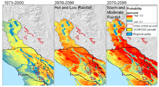 Probability of a fire in the next 30 years, 1971-2099, Sonoma County |
Table of Contents:
Downloads:
|
Sonoma County Agricultural Protection and Open Space District and Regional Parks Responsibilities and Jurisdiction
Sonoma County is fortunate to have two County agencies working in concert to acquire and steward properties that protect and enhance the region's ecological health and provide recreational access for citizens.
The Sonoma County Agricultural Protection and Open Space District (the District) is a voter-supported entity that utilizes dedicated sales tax revenues to strategically acquire conservation and working lands. Sonoma County voters approved Measures A and C to create the District and enable a quarter-cent sales tax to fund District operations until 2011. In 2006, with 76% of the vote, Sonoma County residents approved Measure F to extend the quarter-cent sales tax through 2031. As one of the first organizations in the country established to protect both agricultural and open space lands, the District has protected over 106,000 acres to benefit people and wildlife.
Sonoma County Regional Parks (Parks) operates more than 50 parks throughout the county for both resource value and public access. Many of these parks were originally acquired by the District and then transferred to Parks, as budgets allowed. Regional Parks' mission is to create healthy communities and to contribute to the economic vitality of Sonoma County by acquiring, developing, managing and maintaining parks and trails county-wide. Regional Parks preserves irreplaceable natural and cultural resources, and offers opportunities for recreation and education to enhance the quality of life and well-being of residents and visitors to Sonoma County.
Together the agencies identified a total of 28 parcels (10 parks and 28 open space parcels), that they wish to have assessed in the course of this analysis. Their goal was to think about this combined portfolio of park and open space lands as one resource. Data products focus on advancing our understanding the range and diversity of conditions across the portfolio in the context of Sonoma County as a whole to inform long-term planning. Thus, products are designed to compare and contrast parcels within the selected set as an input for management planning across the county, rather than providing management-level data and recommendations per parcel. At the next step of management planning, the agencies will have the ability to zoom in on large parcels with the raster Basin characterization model data set provided.
Sonoma County Agricultural Protection and Open Space District and Regional Parks Climate-related Concerns and Management Priorities
The District and Parks are both interested in using project results to frame long-term climate smart land acquisition strategies and stewardship management plans. The District is involved with two related initiatives, one to incorporate climate considerations into a regional acquisition plan, and another to quantify the economic value of environmental services generated by protected lands, with a particular focus on watershed functions including water supply and flood attenuation. Parks is on the verge of beginning a comprehensive natural resource management planning effort for their properties, and selected a set of priority parks for this analysis based on a set of internal criteria. Their planning objective is to integrate climate considerations into all natural resource management projects with a planning horizon of five years and beyond in order to meet the goal of providing "resiliency" for existing systems.
Parks is concerned with how current climate variability already impacts operations, particularly the impacts of extreme events on their ability to conduct work and maintain facilities. Extreme storms and floods result in costly damage directly from water and indirectly due to landslide risks, particularly on riverside properties. Flood response requires diverting resources from other programs until damage is repaired. Extreme cold causes infrastructure damage and potential costly repairs. Extreme heat imposes regulatory limits on getting work done, examples include: red flag days that limit maintenance activities using powered equipment; extreme heat days that trigger OSHA safety requirements for outside workers; and spare the air days that trigger prohibition of campground fires.
The current drought has also affected Parks’ operations in a number of ways. The drought has increased the need for irrigation in habitat restoration projects, increased emphasis on water conservation and leak repair, and impacted mowing schedules due to increased fire risks. Parks indicated that they rely on the Sonoma County Water Agency to define a drought for them. The potential upside of the drought has been more visitors resulting in increased revenues due to the sunny weather.
Sonoma County’s park and open space management concerns are grouped into three resource areas: 1) Water Resources (including rainfall, water supply, and drought); 2) Native Vegetation Response; and 3) Fire Risks.
Vulnerability Assessment Results
Key Vulnerability Assessment Findings for Sonoma County
Key findings for Sonoma County include a unidirectional trend, regardless of total rainfall, towards increasing climatic water deficits across model scenarios. Therefore, managers will be facing an increasingly arid environment. Water supply indicators generally increase in variability across all scenarios, with the extreme scenarios ranging from approximately 25% greater to 25% less total watershed supply. The climate suitability for vegetation types in Sonoma County will favor drought-tolerant species, while fire risks are projected to double in especially fire prone regions. The combination of potential drought stress on water supplies and vegetation, with an approximate doubling of fire risks, should inform long-term adaptive management of natural resources. Working with agencies on potential Climate Ready North Bay product applications, the project team is exploring how to build watershed resilience to drought with a focus on protecting groundwater recharge. Drought tolerance also needs to be promoted in forest, rangeland, and agricultural systems, and perhaps more aggressive approaches to the reduction of forest fuel loads should be considered.
- Sonoma County is becoming more arid due to rising temperatures.
- Rainfall is likely to be more variable in the future.
- Runoff may be increasingly flashy, with rates of groundwater recharge potentially less variable over time.
- Protecting recharge areas will be critical to water supply sustainability.
- Water demand for agriculture may increase on the order of 10%.
- Fire frequencies are projected to increase on the order of 20%, requiring additional readiness planning and perhaps more aggressive fuels management.
- Vegetation may be in transition, meriting additional monitoring and consideration of a drought tolerant planting palette for restoration.
Key Management Questions by Resource Area
The following management questions are addressed in the CRNB SCAPOSD and Regional Parks Technical Memo:
Water Resources
Management Question: Which parcels in the combined parks and open space portfolio provide key water supply benefits?
Management Question: Which parcels in the combined portfolio are prone to extreme drought stress?
Native Vegetation Response
Management Question: What kind of transitions in native vegetation may occur on parks and open space lands?
Fire Risks
Management Question: How are fire risks projected to impact the combined portfolio?
Potential Climate Ready Sonoma County Watershed Data Applications
- Use of hydrology and other model outputs to identify potential acquisitions of high water resource and climate resiliency value
- Consideration of data products in prioritizing which parks need comprehensive management plans, and which ones may be vulnerable to relatively high climate impacts
- Integration of results into specific operational considerations of natural resource plans and fire mitigation planning
- Use of materials for community outreach and education
In the process of identifying management concerns and questions, a number of key questions amenable to analysis in the scope of this project were identified and are presented by resource areas below. The following management question was also identified, but the team determined it was beyond the scope of this study, and therefore is not addressed here, but can be addressed using the core data set provided to the District in the process of site specific management planning.
- What parcel-specific management recommendations can be drawn from Climate Ready North Bay data products?
The goal of this project was to assess the set of parks and open space parcels as a whole to look at the range of potential climate impacts across the portfolio. When the agencies begin to develop parcel-specific management plans, the Climate Ready North Bay Basin Characterization Model database, provided as an output of this project, will be available for site-specific planning since it is being transferred to the county for future use. However, the translation of climate vulnerabilities to specific management plans and actions will require another process at the local scale, akin to what Pepperwood is presently doing as a part of its Adaptive Management Plan for its own 3200-acre preserve. The project team would be happy to share that process and plan with the District and Regional Parks when the time is right relative to their planning process.
Back to the North Bay Climate Ready Homepage