Dataset

Baylands Goals Climate Change Scenario Analysis Maps

Commons Hosting
Climate Commons Hosting Status: 
Not applicable
Basic Information

These maps were produced for the Baylands Ecosystem Habitat Goals Update team and constitute a common set of maps for use across the working groups.

Maps included are:

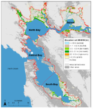
Marsh accretion with high and low sediment supply, and high and low sea level rise, shown as elevations and habitat type, for the entire San Francisco Bay Estuary and zoom-ins for the Delta/Suisun Bay, South SF Bay, and San Pablo Bay study segments.

Graphic representation of the projected habitat types for each sediment/SLR scenario, for the SF Bay Estuary subregions.

Suspended sediment estimates for the 15 biogeomorphic subregions (background information).

Sources of elevation data for the regions (background information).

Creator: 
Point Blue Conservation Science
Contributor: 
CA LCC
Publisher: 
Climate Commons
Collection:
Temporal Coverage: 
2010--2110
Date Issued: 
May 19, 2014
Parameters / Choices
A dataset often contains many geodata layers representing the same kind of measurement, but for different values of some parameters - time periods, models or scenarios, different species, etc. A value must be chosen for each such parameter in order to select a specific layer or raster which associated a single value with each geographic location (cell). The parameters or choices relevant to selecting layers from this dataset are described here.
Climate Models: 
Time Units: 
2010, 2030, 2050, 2100
File Attachments