
Carbon Sequestration
What is Carbon Sequestration?
|
Carbon sequestration refers to long-term storage of carbon to either mitigate or defer the impacts of global warming through slowing the atmospheric accumulation of the greenhouse gas carbon dioxide. Management of forests or other natural ecosystems so as to sequester carbon has become a topic of considerable policy interest. The following outlines resources that are of particular interest to carbon sequestration on natural landscapes in California.
A general overview of the current knowledge regarding carbon sequestration in US forests has been compiled in McKinely et al. 2011, while Fahey et al. 2010 provide a recent review of management and policy associated with the use of forested lands as a means of carbon storage. |
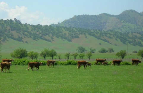 California's rangelands contribute to carbon storage. The CA LCC project “Threat assessments on California rangelands” analyzed how the carbon sequestration potential of California rangelands may be impacted by future climate and land use changes. |
Perhaps the first study to try to quantify carbon storage across all of California's forests and rangelands was Brown et al. 2004. This project used the Multi-source Land Cover data from the Fire and Resource Assessment Program of the California Department of Forestry and Fire Protection as a land cover base for its models. More recently, CDF-FRAP has discussed carbon storage on California's forests as part of their 2010 forest and rangeland assessment. Several regional studies of carbon storage in the California landscape include Hudiberg et al. 2009, discussing forest carbon stocks in the Cascade Ranges, Brown et al. 2007, concerned with afforestation in Shasta County, Graham et al. 2002 dealing with soil carbon in Southern California chaparral watersheds, Knox et al. 2014 assessing carbon storage possibilities in the Sacramento-San Joaquin delta, and Williams et al. 2011 who discuss measuring stored carbon in a mixed woodland-vineyard landscape in Mendocino County. Gonzalez et al. 2010 also discuss measurement issues in a study comparing forest carbon estimates using field plots, Quickbird high-resolution satellite imagery, and Lidar data. |
|
The relationship between carbon storage and wet meadows is well established. Meadow restoration is a priority of the California Department of Fish and Wildlife as part of their greenhouse gas reduction program because re-watering meadows is expected to reduce the rate of peat oxidation and soil carbon loss.
Rangelands have been of particular interest with regards to carbon sequestration because they cover a large portion of California and provide many beneficial ecosystem services. The CA LCC project “Climate change/land use change scenarios for habitat threat assessments on California rangelands” analyzed the carbon sequestration potential of California rangelands and how it may be impacted by future climate and land use changes. The project summary includes data about the possible changes to the ecosystem services provided by rangelands in the Central Valley, Chaparral and Oak Woodlands eco-regions. The findings for this project are presented in Byrd et al. 2015. A protocol for assessing carbon storage on forestlands has been developed by the Climate Action Reserve to serve as a basis for issuing carbon offset credits as part of a carbon market. Cap and trade has been utilized throughout the U.S. in order to provide incentives for the reduction of pollutant emissions. Information about California’s cap and trade program can be found on the California Environmental Protection Agency’s website. |
 Indian Valley Meadow is the site of a restoration project that will enhance carbon storage as well as important hydrologic services. Photo by Chuck Loffland. |
Mapping Landscape Carbon Stores
 LandCarbon, an online tool for evaluating landscape carbon storage. |
The National Biomass and Carbon Dataset is the first high-resolution dataset providing standing biomass and carbon stock for the conterminous United States. LandCarbon is an interactive tool produced by the USGS that allows for an interactive look at land carbon data throughout the United States. |
For further reading and resources, please click on the subject tags below.
6/2015