
Understanding Sea Level Rise
One of the impacts of climate change is sea level rise, which threatens coastal areas with increased erosion and flooding, and estuarine systems with loss of habitat. Sea level is expected to rise significantly over the next century due to rising temperatures caused by increasing atmospheric greenhouse gas concentrations.
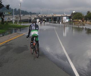 This photo of the Stinson Beach off-ramp at high tide is part of the California King Tides Project to document sea level rise. |
Why Is Sea Level Rising? There are two main factors contributing to rising sea levels across the globe, both caused by a warming global climate. Ocean thermal expansion, or the increase in volume of the oceans as sea water temperatures rise, is responsible for about half of the global rise in sea levels. Melting land-based ice, from glaciers and ice caps, contribute the other half. Differences in coastal land elevation changes from isostatic rebound, tectonic plate movement, and land subsidence are factors in the relative sea level, the difference in elevation between the height of the sea surface and the height of the land surface at any particular location. |
|
How Fast is Sea Level Rising? Tide gauges show that mean sea level has risen along the California coastline about 7 inches during the 20th century. Recent data shows that the rate of global sea-level rise is accelerating. The rate of change in relative sea level is different across the California coastline, because it is determined by local coastal conditions. |
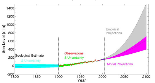 Estimated, observed, and projected global sea-level rise from 1800 to 2100, from Sea-Level Rise for the Coasts of California, Oregon, and Washington: Past, Present, and Future (2012). |
|
Sea-level rise rates recorded at NOAA tide gauges for Southern and Central California range from just under 1 mm/year to just over 2 mm/year, while the state's coastline north of the Cascadia Subduction Zone boundary near Cape Mendocino where the ocean plate moves under the continental plate, the coastline on average is rising more rapidly than the rate of sea-level rise. An exception to this is the Humboldt Bay region, where land subsidence contributes to relative sea-level rise rates that are two to three times greater than anywhere else in California. In addition to land movement, bathymetry and tidal action can create sea levels that are very different between two nearby areas of coastline, as is seen in the northern and southern parts of the San Francisco Bay. El Niño events cause temporary increases in sea levels along the California coast. This website from San Francisco Baykeeper shows historical data with several projections for the region. Note how El Niño years show a marked increase in sea level rise. An earthquake magnitude 8 or larger, which occurs in the region every few hundred to 1,000 years, could cause the land to drop and relative sea level to suddenly rise. Storms can change sea level dramatically on a local scale, and large waves from storms combined with the interaction between runoff and high tides are a concern as some research predicts increasingly intense and more frequent storm events. CalAdapt lets you explore maps of potential inundation areas for different degrees of sea-level rise along the coast of California and the San Francisco Bay. |
|
Projecting the Future
The most recent projections of sea-level rise for California are presented in the report Rising Seas in California: An Update on Sea-Level Rise Science (Griggs et al., 2017). This document provides an excellent synthesis of the current state of the science on sea-level rise.
Prior to this report there were four reports that provided estimates of future projected sea level rise for California. These scenarios are the basis of the vulnerability assessments and web tools created before 2017. These are:
- Sea-Level Rise for the Coasts of California, Oregon, and Washington: Past, Present, and Future, 2012
- Coastal and Ocean Working Group of the California Climate Action Team 2013 update to the State of California Sea-Level Rise Guidance Document
- Global sea level linked to global temperature Martin Vermeer and Stefan Rahmstorf, 2009
- IPCC. Climate Change 2007: Synthesis Report. Contribution of Working Groups I, II and III to the Fourth Assessment Report of the Intergovernmental Panel on Climate Change, 2007
You can easily see what these reports predict for California's coastline by using this Sea Level Rise Projection tool from the OCOF project.
In their publication Climate change projections of sea level extremes along the California coast, Cayan et al. 2008 combine information on predicted tides, weather forcing, and El Niño-related variability to estimate the height of extreme events on coastal California up to the year 2100.
Impacts of Rising Seas and Tides
A number of studies have tried to evaluate the potential impacts of sea level rise on California. The National Research Council released a report and educational video in 2012 explaining the factors that cause regional variation in sea level rise along the west coast of the United States, including climate patterns such as the El Niño, effects from the melting of ice sheets, and geologic processes, such as plate tectonics. For coastal areas. Revell et al. 2011 use coastal geology to predict possible erosion distances, and Heberger et al. 2011 evaluate the potential economic and population impacts of coastal flooding. The Heberger et al. study also makes available their GIS datasets. Hanak and Moreno 2012 describe California coastal vulnerabilities and management options, including coastal armoring, beach nourishment, and living coastline management practices.
The potential impacts of sea level rise in San Francisco Bay and the Delta region have also attracted considerable attention. Using a hydrodynamic model of the San Francisco estuary, Knowles 2009 investigated potential inundation areas for the Bay and Delta out to the year 2100. Cloern et al. 2011 give projections for a set of indicators for the region under climate change, including water and air temperature, salinity, sediment loading, and extreme water levels. This work has emerged from an hydrodynamic modeling effort at the USGS called CASCaDE. The online tool Our Coast Our Future supports exploration of impacts to coastal resources from sea level rise, storm surge, and wave action. The tidal marshes in San Francisco Bay are another focus of interest. The interactive mapping tool Future San Francisco Bay Tidal Marshes allows users to explore the impact of sea level rise on tidal marsh habitat and bird distributions, and Stralberg et al. 2011 evaluate the potential for natural marsh sustainability under a high sea level rise scenario.
Learn More
These short videos explain sea level rise, why it is happening, how fast it is happening, the various projections of the future, and the types of impacts it is expected to have along the west coast and San Francisco Bay:
Presentation given in November, 2012 by Tom Suchanek, Climate Change Coordinator, Western Ecological Research Center, USGS.
Educational video from the The National Research Council.
Related resources:
Search the Commons: Sea level rise
Resources for Evaluating the Impacts of Sea Level Rise
Sea Level Rise Analysis Tools
8/2017