
Sea Level Rise Analysis Tools
Listed here are software-based utilities designed to provide an analysis framework and input data for assessing impacts to natural resources and built environments by sea level rise. Research projects, documents, and programs with broader scope are listed separately.
See also: Resources for Evaluating the Impacts of Sea Level Rise
12/2012
| Title | Tool Form | Tool Theme | Geo Focus | Creator | Description | Demo Link |
|---|---|---|---|---|---|---|
CalAdapt Threatened Areas Maps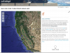 |
Web based | Sea level rise | California | UC Berkeley Geospatial Innovation Facility |
Map tool displays areas that may be in threat of inundation during an extreme flood event (100 year flood) for current and three projected sea levels. Uses a simple "bathtub" model; maps are available for the entire coastline. |
|
Coastal Resilience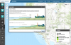 |
Web based | Sea level rise, Tidal marshes | Coastal California | The Nature Conservancy |
Flexible online ESRI-based mapping tool with many data layers intended for use in coastal community planning, allowing for consideration of approaches to address sea level rise adaptation for habitats and human infrastructure. Allows user to create custom maps and generate a URL to use for sharing the map and data or embed it in another website. |
Built-in Tour |
Future San Francisco Bay Tidal Marshes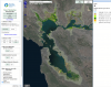 |
Web based | Tidal marshes | San Francisco Bay and Estuary | Point Blue Conservation Science |
Allows the user to select sea-level rise and sedimentation scenarios to examine future tidal marsh habitat change in the San Francisco Bay Estuary over the next 100 years. |
Tutorial video |
NOAA's Sea Level Rise and Coastal Flooding Impacts Viewer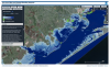 |
Web based | Coastal communities, Tidal marshes, Socioeconomics | Coastal United States, California | NOAA |
Online map-generation software that overlays social and economic data onto potential sea level rise data for a view of potential impacts on communities and tidal marshes from inundation and tidal flooding. |
Explaining the NOAA Sea Level Rise Viewer |
Our Coast Our Future (OCOF)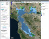 |
Web based | Sea level rise, Extreme events, Flooding | Coastal Central California, San Francisco Bay and Estuary | Point Blue Conservation Science |
A decision support tool developed with the user community to support understanding of infrastructure and ecosystem vulnerabilities from sea level rise and storm hazards. The model incorporates factors such as water levels, wave heights, flooding, and erosion. |
Tutorial videos |
Sea Level Rise and Coastal Flood Web Tools Comparison Matrix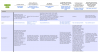 |
Spreadsheet | Sea level rise | California | Climate Central |
This matrix was created to provide the planning and coastal management communities with an expandable chart to compare the functions and methods of publicly available sea level rise and coastal flood web tools. |
|
Sea Level Rise Projection Comparison Tool |
Web based | Sea level rise | Coastal United States | Point Blue Conservation Science |
These dynamic graphs from the OCOF Program provide a comparative look at some of the most commonly cited sea level rise reports. |
|
SLAMM - Sea Level Rise Affecting Marshes Model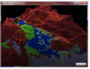 |
Desktop GIS | Tidal marshes | Coastal United States | Warren Pinnacle Consulting, Inc. |
This mathematical model requires the use of MS Excel and ArcGIS. It uses digital elevation data and other information to simulate potential impacts of long-term sea level rise on wetlands and shorelines. |
|
SLAMM-View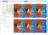 |
Web based | Tidal marshes | Coastal United States, National Wildlife Refuges | Image Matters, LLC; USFWS |
A web browser-based application that provides tools for improved understanding of results from research projects that employ the Sea Level Affecting Marshes Model (SLAMM). SLAMM-View presently provides access to the digital geospatial data results from SLAMM simulations run for three regional Projects, and seven site-specific Projects (see list on their website) as well as 68 additional site-specific Projects from simulations run for National Wildlife Refuges (NWR). |
Demo website |
Surging Seas Risk Finder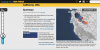 |
Web based | Sea level rise | World | Climate Central |
A suite of interactive tools: maps of areas below different amounts of sea level rise and flooding, area timelines of risk, statistics about SLR impacts by city, county and state, and links to factsheets, data downloads, action plans, and more. |
|
The Impacts of Sea-Level Rise on the California Coast: Sea-Level Rise Maps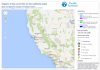 |
Web based | Sea level rise, Coastal communities | California | Pacific Institute; California Energy Commission |
Interactive maps show the threat of inundation due to flooding over three depths based on a 100-year flood scenario starting at MHHW, areas at risk from erosion in 2100 with a 1.4 m SLR, and areas where wetlands may migrate by 2100 if unimpeded. |
|
USGS CASCaDE Potential Inundation due to Rising Sea Levels in the San Francisco Bay Region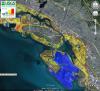 |
Web based | Sea level rise | San Francisco Bay and Estuary | USGS |
This visualization shows a color-coded representation of vulnerability to inundation by average 100-year high-water levels for different amounts of sea level rise. Does not take levees into account; areas behind levees would only be inundated if those structures were to fail. |