Developing Scenarios
A scenario is a plausible yet simplified description of how the future may develop based on a set of assumptions about the main causes of change. Scenarios are neither predictions nor projections, but are based on a narrative storyline about the future (Carpenter et al. 2005). To develop scenarios we leveraged products from two USGS efforts – downscaled land-use land-cover (LULC) change scenarios and downscaled global climate models (GCMs). Both of these efforts are based on the storylines of the Intergovernmental Panel on Climate Change (IPCC) Special Report on Emission Scenarios (SRES) A2, A1B, and B1 (http://www.ipcc.ch/pdf/special-reports/spm/sres-en.pdf). These scenarios have been labeled as A2: "Population Pressures", A1B: "Wealth and Technology" and B1: "Sustainability" based on their distinguishing characteristics.
We paired each LULC change scenario with two statistically downscaled GCMs – one that represents a warm, wet future and one that represents a hot, dry future. While the scenarios originate from SRES narratives, they have been translated to reflect dominant changes to California rangelands. Scenarios vary by extent and distribution of development and irrigated agriculture, extent and distribution of future conservation lands, and changes in climate and hydrology (Table 1). GCMs included variables for minimum or maximum temperatures, which were considered important determinants of vegetation distribution. The GCMs selected for each emission scenario are summarized in Table 2.
The USGS uses a probabilistic growth model, FORE-SCE, (FORecasting SCEnarios of future land cover) to model the distribution of each land cover type across a landscape. We ran the FORE-SCE model for two EPA Level III ecoregions, Central Valley and Chaparral and Oak Woodland. The extent of these ecoregions matches the California Rangeland Conservation Coalition (CRCC) focus area map (http://www.carangeland.org/focusarea.html). Model outputs are maps of LULC change generated yearly from 2006 to 2100 at a spatial resolution of 250 meters. Underlying climate and hydrological variables for each scenario are also available in raster format at 250 meter resolution.
Table 1. Summary of land use-land cover change scenarios for the California rangelands threat assessment
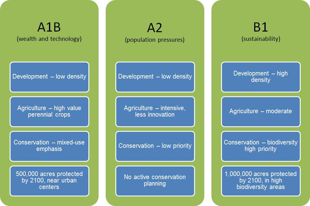
Table 2. Summary of Global Climate Models (GCMs)
|
Emission scenario
|
Hot, dry scenarios
|
Warm, wet scenarios
|
|
A2
B1
|
GFDL = GFDL CM2.1 model, NOAA Geophysical Fluid Dynamics
Laboratory
|
PCM = National
Center for Atmospheric Research and Department of Energy Parallel Climate
Model
|
|
A1B
|
MIROC = MIROC 3.2 (medres), Model for Interdisciplinary
Research on Climate, Japan
|
CSIRO = CSIRO Mark 3.5, Commonwealth Scientific and
Industrial Research Organisation, Australia
|
Ecosystem Services Modeling
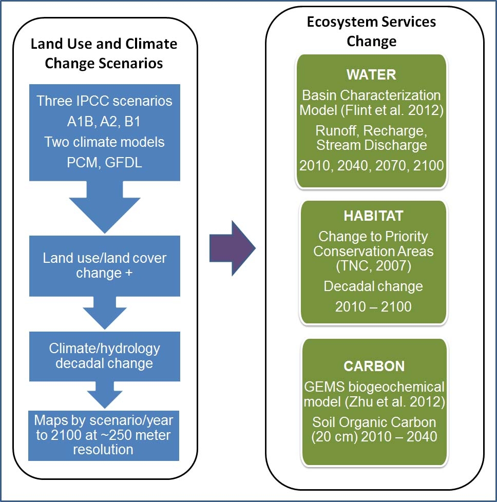
Ecosystem services are the benefits people obtain from ecosystems. These include provisioning services such as food and water; regulating services such as flood and disease control; cultural services such as spiritual, recreational, and cultural benefits; and supporting services such as nutrient cycling that maintain the conditions for life on Earth (Carpenter et al. 2005). We are using scenarios to quantify wildlife habitat, water supply and carbon sequestration benefits of rangeland conservation, and to conduct an economic analysis associated with changes to these ecosystem services. We used the USGS Basin Characterization Model (BCM) (Flint and Flint, 2012, Flint et al. 2013, Thorne et al. 2012) to model change in runoff, recharge, and stream discharge based on LULC change and climate change. We tracked change in rangeland soil carbon stocks with USGS General Ensemble Biogeochemical Modeling System (GEMS) output (http://www.usgs.gov/climate_landuse/land_carbon/default.asp). We modeled future change to wildlife habitat by quantifying land use change in critical priority conservation areas in the CRCC focus area (TNC, 2007) (Figure 1).
Figure 1. Modeling changes to rangeland ecosystem services
Based on workshop feedback we developed a list of metrics to be derived from model outputs that translate our scenarios into information that is relevant to ranchers, land managers, planners and other decision-makers' needs. Results are presented for the CRCC focus area at the scale of HUC-8 watersheds (http://water.usgs.gov/GIS/huc.html). This website provides a visualization tool to view changes in metrics across scenarios and years.
References
Carpenter, S. R. et al. (eds). 2005. Ecosystems and Human Well-being: Scenarios, Volume 2. Appendix D, Glossary. Findings of the Scenarios Working Group, Millennium Ecosystem Assessment. Island Press, Washington. Available online at: http://www.maweb.org/en/Scenarios.aspx#download.
Flint, L.E. and Flint A.L. 2012. Downscaling future climate scenarios to fine scales for hydrologic and ecologic modeling and analysis. Ecological Processes 1:2. Available online at: http://www.ecologicalprocesses.com/content/1/1/2.
Flint, L.E., A.L. Flint, J.H. Thorne, and R. Boynton. 2013. Fine-scale hydrologic modeling for regional landscape applications: the California Basin Characterization Model development and performance. Ecological Processes 2:25. Available online at: http://www.ecologicalprocesses.com/content/2/1/25
The Nature Conservancy (TNC). 2007. California Rangeland Conservation Coalition Biological Prioritization of Rangelands: Approach and Methods. Available online at: http://www.carangeland.org/images/Appraoch_and_Methods.pdf.
Thorne, James, Ryan Boynton, Lorraine Flint, Alan Flint, and Thuy-N’goc Le (University of California, Davis and U.S. Geological Survey). 2012. Development and Application of Downscaled Hydroclimatic Predictor Variables for Use in Climate Vulnerability and Assessment Studies. California Energy Commission. Publication number: CEC-500-2012-010.
Zhu, Zhiliang, and Reed, B.C., eds., 2012, Baseline and projected future carbon storage and greenhouse-gas fluxes in ecosystems of the Western United States: U.S. Geological Survey Professional Paper 1797, 192 p. Available online at: http://pubs.usgs.gov/pp/1797/.