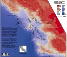
SF Bay Area Map of Average Summertime Hours of Fog & Low Cloud Cover Per Day

Fog and low cloud cover (FLCC), is very important for coastal California during the seasonally arid Meiterranean climate summer month s (June – September). The low stratus and stratocumulus clouds form ov er the ocean, adv ec t onsh ore as fog and low clouds altering the water, energy, and nutrient flux of coastal ecosystem s. Precisely located fog belt zones an be used to quantify the impacts of FLCC on ecosystem dynamics. The water and shade cover that FLCC provides during hot and dry summer periods is especially critical for endan ered species such as coho salmon. This contour map shows average daily summertime hours in 30 minute intervals. More than 26,000 hours of weather satellite imagery from 1999 to 2009 were used to generate the contours. The Cooperative Institute for Research on the Atmosphere classified the imagery into hourly cloud maps using the satellite sensor data in the visible, shortwave, and near infrared bands and USGS compressed the data to make th is map. For more details see: Torregrosa, A., C. Comb s, and J. Peters (2016), GOES-derived fog and low loud indices for coastal north and central California ecological analyses, Earth and Space Science, 3, doi:10.1002/2015EA000119.
SF Bay Area Map of Average Summertime Hours of Fog & Low Clouds Per Day. 2016. Torregrosa, A., C. Combs, and J. Peters. USGS.
