Dataset

Bird Species Richness Response to Climate Change

Commons Hosting
Climate Commons Hosting Status: 
Available
Discussion Forum
Basic Information

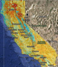
Species richness indicates the number of different species predicted to be able to occur at a location. Maps show the projected species richness under current climate and two models of future climate conditions. Species richness is calculated by converting the predictions from maxent models into binary maps of presence and absence and summing the maps across all species. Higher values in the maps indicate where more bird species are projected to be able to occur.

Creator: 
Point Blue Conservation Science
Spatial Resolution: 
800m
Parameters / Choices
A dataset often contains many geodata layers representing the same kind of measurement, but for different values of some parameters - time periods, models or scenarios, different species, etc. A value must be chosen for each such parameter in order to select a specific layer or raster which associated a single value with each geographic location (cell). The parameters or choices relevant to selecting layers from this dataset are described here.
Climate Models: 
Emission Scenarios: 
Multi-year Ranges: 
1971-2000, 2038-2069
Raster Grids available: