Dataset

North American Regional Climate Change Assessment Program

Commons Hosting
Climate Commons Hosting Status: 
Eligible
Basic Information

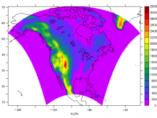
The North American Regional Climate Change Assessment Program (NARCCAP) is an international program to produce high resolution climate change simulations in order to investigate uncertainties in regional scale projections of future climate and generate climate change scenarios for use in impacts research. NARCCAP modelers are running a set of regional climate models (RCMs) driven by a set of atmosphere-ocean general circulation models (AOGCMs) over a domain covering the conterminous United States and most of Canada.

Creator: 
National Center for Atmospheric Research
Publisher: 
National Center for Atmospheric Research
Collection:
Spatial Resolution: 
50 km
Date Issued: 
2012
Parameters / Choices
A dataset often contains many geodata layers representing the same kind of measurement, but for different values of some parameters - time periods, models or scenarios, different species, etc. A value must be chosen for each such parameter in order to select a specific layer or raster which associated a single value with each geographic location (cell). The parameters or choices relevant to selecting layers from this dataset are described here.
Climate Models: 
Emission Scenarios: 
Time Units: 
3-hourly
Multi-year Ranges: 
2041-2070