Dataset

Magnitude of Climate Change

Commons Hosting
Climate Commons Hosting Status: 
Available
Discussion Forum
Basic Information
Full Title: 
Environmental Change Network: Local Climate Change

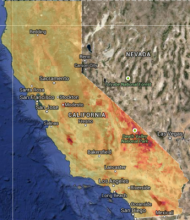
These maps display the magnitude of projected future climate change in relation to the interannual variability in late 20th century CA climate. The maps show the standardized Euclidean distance between the late 20th century climate at each pixel and the future climate at each pixel. The standardization puts all of the climate variables included on the same scale and down weights changes in future climate which have had large year to year variation historically. Warmer colors indicate greater climate change and cooler colors indicate less extreme climate change.

Creator: 
Point Blue Conservation Science
Publisher: 
PRBO Conservation Science
Subjects:
Spatial Resolution: 
800m
Date Issued: 
2011
Parameters / Choices
A dataset often contains many geodata layers representing the same kind of measurement, but for different values of some parameters - time periods, models or scenarios, different species, etc. A value must be chosen for each such parameter in order to select a specific layer or raster which associated a single value with each geographic location (cell). The parameters or choices relevant to selecting layers from this dataset are described here.
Climate Models: 
Emission Scenarios: 
Raster Grids available: