
How to Use the "Threat Assessments on California Rangelands" Maps to Inform Land Use Decisions
This page is intended to help people incorporate the Threat Assessments on California Rangeland Maps into plans and decisions that affect local land use.
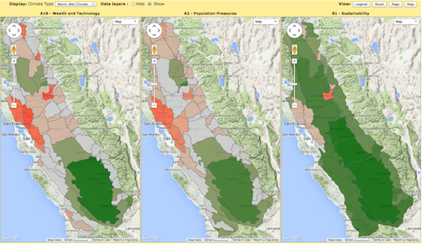
Above: A trio of maps comparing Average Percent Change in Multiple Ecosystem Services (carbon, habitat, and water) projected using a "warm, wet" climate model with three different emissions scenarios.
Introduction to the Maps
Maintaining a ranching landscape can greatly support biodiversity conservation in the California Landscape Conservation Cooperative (CA LCC) region. In addition, ranches generate multiple ecosystem services—defined as human benefits provided by natural ecosystems—that carry considerable economic value, including livestock production, drinking and irrigation water, and carbon sequestration.
Climate change and rangeland scientists, ranchers, and land managers have worked together to develop six scenarios to address a primary management question: How can we maintain viable ranchland and their ecosystem services in light of future integrated threats? The scenarios represent alternative futures of climate/land use/hydrological change for the California Rangeland Conservation Coalition (Rangeland Coalition) focus area (the Central Valley, surrounding foothills, and most of the southern Inner Coast Range).
Scientists used these scenarios to quantify and map three main rangeland ecosystem services—wildlife habitat, water supply, and carbon sequestration. This climate change-informed assessment can be explored through a web-based visualization tool that allows users to view changes in these ecosystem services across scenarios and years.
See the Rangeland Maps website for background information about how these maps were made.
Explore the available maps with these quick links:
Carbon SequestrationPercent change in grassland soil carbon sequestration potential All Ecosystem Services Combined |
How to Use These Maps
These maps represent alternative future scenarios for California rangelands that encompass high growth scenarios (A2, A1B) and a sustainable growth scenario (B1), each paired with a warm, wet climate projection and a hot/dry climate projection. The maps are not predictions. Results are summarized at the scale of the HUC-8 watershed to give a CA LCC-wide view of potential changes to ecosystem services, and to account for uncertainties in the scenarios at the site level. The three-map viewer shows results for each scenario simultaneously for a given metric. The user can toggle “Climate Type” and choose between the metrics Climatic Water Deficit, Recharge/Runoff Ratio, Water-Wildlife Hotspots, and Multiple Ecosystem Services to see how metrics vary between a warm, wet climate projection and a hot, dry climate projection. Also, for the metrics Critical Habitat, Climatic Water Deficit, Recharge/Runoff Ratio, and Water-Wildlife Hotspots the user can toggle “Year” to see how metrics change for years 2040, 2070, and 2100. Users may click on a watershed to display the metric data.
Overall, these maps demonstrate the important role of rangelands in providing multiple ecosystem services. The maps show how vulnerability to rangeland benefits varies across the CA LCC region as well as the potential rate of change in these benefits over this century. For example, maps of change in a combined average of three ecosystem services – soil carbon sequestration, wildlife habitat, and water availability – show that certain watersheds such as those surrounding the San Francisco Bay and near Redding and Sacramento experience greater loss of ecosystem services than others by 2040, even under the more optimistic scenario (B1). This pattern is present for the warm/wet projections as well as the hot/dry ones. Also, a map of water-wildlife hotspots, where declines in water availability and loss of priority habitat coincide, show that only one hotspot exists by 2040 – Suisun Bay in the A1B scenario. By 2100 four watersheds show consistent loss in habitat and water across all scenarios – Suisun Bay, Lower Butte, Sacramento-Lower Thomes and Estrella. While most metrics show variation in ecosystem services change across the CA LCC region, maps show that climatic water deficit (a metric related to drought stress on plants and soils) increases under all scenarios by as much as 30%. These consistent projections of increases in climatic water deficit identify the need for region-wide adaptation to these changing climate conditions.
This information can be used to prioritize watersheds for conservation of wildlife habitat and soil conservation, and identify which watersheds are important for water recharge and maintaining water supply. In addition the maps can be used to prioritize where to direct outreach efforts. Conservation organizations have discussed the potential for creating incentives to maintain and enhance ecosystem services on private ranchlands. These maps identify where incentives may be most needed. On the flip side, organizations are interested in using these maps to identify areas that are resilient to climate change and change in water supply, which could serve as important corridors for conservation in the future.
In addition these maps have the potential to inform new landscape-scale planning initiatives.
A new program that addresses conservation in the Central Valley is the CA Department of Conservation’s Sustainable Agricultural Land Conservation Program, which was formed to protect critical agricultural lands from conversion to urban or rural residential development as a strategy to reduce greenhouse gas emissions. The program will fund the acquisition of easements and other approaches or tools that protect agricultural lands vulnerable to conversion to urban or suburban sprawl or those of special ecological value. The maps could help cities and counties prioritize areas that provide multiple ecosystem services and are more resilient to climate change. Directing conservation to those areas will result in a more effective and efficient use of the public’s investment in conservation. In addition the maps will help direct development to those areas where the loss of ecosystem services will be minimized.
Another program that will benefit from the maps and data generated by this project is the CA LCC’s Central Valley Landscape Conservation Project, which aims to coordinate conservation efforts to help Central Valley landscapes mitigate and adapt to climate change.
Obtaining the Data
 |
The shapefiles used in the map tool summarizing the project metrics for the HUC-8 watersheds can be downloaded from this catalog record: California Rangeland Threats, summary by HUC watershed.
|
About Using the More Detailed Raster Data
Used at the appropriate scale, the raster data can support more detailed, sub-watershed planning. We recommend summarizing the recharge and runoff data by the HUC-12 subwatershed boundary scale. A shapefile of the HUC-12 subwatersheds for California can be obtained from the USGS. Climatic water deficit (CWD) data may be used at the subwatershed scale where energy load calculations are quite accurate, but uncertainty is associated with the soil properties used in the model and on a fine scale, such as the pixel scale, should be verified in the field. For more information on how to best use the underlying raster data for planning see “How to use rangeland raster data.”
For example, by comparing the baseline 1981-2010 CWD data to future CWD projections, managers can begin to understand what parts of the watershed are the most or least resilient to climate change. This climate resiliency can have implications for forest health, wildfire, invasive species, biodiversity, and species distributions. The soils data can be used to better understand the soil properties of the watershed. In particular the soil depth data can help identify where water can be maintained. The recharge, runoff and recharge/runoff ratio data can help guide where to optimize water storage, enhance groundwater recharge, and preserve recharge zones. Together these hydrological data can support strategic, climate smart land use choices that can aid species protection and help maintain a permeable watershed and water supply.
You may also read more about and get access to the California Basin Characterization Model Dataset on the Climate Commons.
Related References:
Byrd, K.B., L. Flint, P. Alvarez, C.F. Casey, B.M. Sleeter, C.E. Soulard, A. Flint and T. Sohl. 2015. Integrated climate and land use change scenarios for California rangeland ecosystem services: wildlife habitat, soil carbon and water supply. Landscape Ecology. DOI: 10.1007/s10980-015-0159-7 (Open Access)
Byrd, K.B., B. Sleeter, L. Flint, C. Soulard, P. Alvarez, F. Casey and T. Sohl. 2014. Integrated scenarios and outreach for habitat threat assessments on California Rangelands. Chapter 3.7 in: Erika L. Rowland, Molly S. Cross, and Holly Hartmann (eds.). Considering Multiple Futures: Scenario Planning To Address Uncertainty in Natural Resource Conservation. U.S. Fish and Wildlife Service. 162 pp. http://www.fws.gov/home/climatechange/pdf/Scenario-Planning-Report.pdf
Byrd, K., Alvarez, P., Flint, L., and Flint, A., 2014, Future Scenarios of Impacts to Ecosystem Services on California Rangelands: U.S. Geological Survey Fact Sheet 2014–3019, 2 p., http://dx.doi.org/10.3133/fs20143019.
Elizabeth A. Chornesky, David D. Ackerly, Paul Beier, Frank W. Davis, Lorraine E. Flint, Joshua J. Lawler, Peter B. Moyle, Max A. Moritz, Mary Scoonover, Pelayo Alvarez, Kristin Byrd, Nicole Heller, Lisa Micheli, Stu Weiss. 2015. Adapting California’s Ecosystems to a Changing Climate. Bioscience.
6/2017