
Wildfire and Climate Change
|
Fire is a staple of California's Mediterranean climate due to the combination of atmospheric factors leading to cool, wet winters with increased vegetation growth creating an abundant fuel source for fire-prone, hot, dry summers. However, wildfire intensity and frequency has the potential to increase as a result of the current climate trends. Extreme cases of hotter and drier summers, with little precipitation throughout the year could drastically alter the fire regime and impact the ecosystems, infrastructure and landscape of California. This article reviews current research into the the interactions of wildfire and climate change and provides an overview of data and tools for projecting future changes in fire and its impacts on biodiversity. |
Photo from the August, 2013 Yosemite Rim Fire by NASA Earth Observatory. |
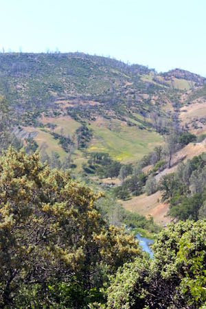 A burned area in Lake County recovers and wild flowers bloom. Photo by Andrea Graffis, CA LCC. |
Current research: interactions of wildfire and climate changeA number of researchers have examined the potential impact of climatic change on the frequency and intensity of wildfires in California. Westerling et al. 2006 reviewed wildfire activity in the western United States since 1970 and concluded that wildfire activity increased markedly in the 1980s. Westerling and Bryant 2007 model wildfire risk in California under four climatic change scenarios, taking into account changes in climate and hydrology. Westerling and colleagues (Westerling et al. 2009, Westerling et al. 2012) have also looked at predictions for future wildfire regimes for California in relationship to urban growth projections and the wildland-urban interface. Baltar et. al 2014 similarly focus on the combined effects of urban population growth and climate change on fire frequency and area burned in 49 California counties. Prolonged changes in weather patterns have been linked to increased wildfire risk and have therefore been useful in correlation based wildfire studies. Stavros et al. 2014 developed regression-based models to predict the likelihood of very large wildfires based on climatic conditions across the Western United States for eight National Interagency Fire Center Geographic Area Coordination Centers (GACCs). These models were further developed in Stavros et al. 2014 to include probability of very large wildfires in 5 regions: the Eastern Great Basin, Northern Rockies, Pacific Northwest, Rocky Mountains, and Southwest. The correlation between meteorological data and wildfire in Southern California was analyzed by Yue et al. 2014 using parameterization and regressions to estimate total present and future area burned. For the Sierras, the link between weather patterns and fire frequency has been analyzed by Collins 2014. |
Fire and California's biodiversityChanges in the fire regime as a result of climate change will have many implications on the ecosystem services provided by the California landscape. Hannah et al. 2011 consider wildfire risk as one factor out of several under climate change that could affect timber production. Moritz and Stephens 2008 suggest management and policy changes in light of wildfire risk given climate change. Bonebrake et al. 2014 analyze several management strategies for protecting the biodiversity of obligate seeding plants from multiple stressors, including increased fire regime frequency. Duguy et al. 2013 provide a method for identifying, managing and restoring fire-prone ecosystems in a Mediterranean climate. |
Data, tools, and modelingThere are several tools and datasets available that may be useful when dealing with wildfire in California. LANDFIRE is an interagency vegetation, fire, and fuel characteristics mapping program that provides data that is essential to wildfire management planning. MesoWest is an interactive site that collects weather/atmospheric info from around the US. Available data that could pertain to wildfire management includes: NEXRAD Radar, precipitation grids, temperature contours, wind speed contours, active fire perimeters, hot spots, and smoke plumes. The MC1 Simulation Results California can be used to look at simulations of vegetation, carbon cycle, and wildfire under current and future conditions. The California Basin Characterization Model Dataset provides historic and projected climate and hydrology layers useful in examining factors important to wildfire frequency and intensity. |
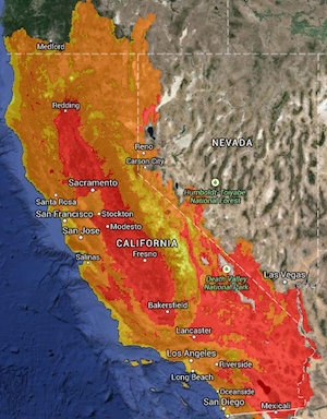 Projected 2070-2099 August maximum temperature, using a hot/dry (MIROC ESM RCP 8.5) model with the Basin Characterization Model (Flint and Flint, 2014) |
6/2015