
Vulnerability Assessment Tools
Listed here are software-based utilities designed to provide an analysis framework and input data for assessing vulnerability of natural resources and built environments to the impacts of climate change. Guidance documents, case studies, modeling programs, and more broadly-applicable data access portal and visualization systems are listed separately.
Related Resources:
Resources for Conducting a Vulnerability Assessment
Resources for Evaluating the Impacts of Sea Level Rise
1/2013
| Title | Tool Form | Tool Theme | Geo Focus | Creator | Description | Demo Link |
|---|---|---|---|---|---|---|
Template for Addressing Climate Change Impacts and Management Options (TACCIMO) |
Web based | Forest planning | United States | USDA Forest Service Partnership |
The Template for Assessing Climate Change Impacts and Management Options (TACCIMO) is a literature review and annotated publication database of climate change knowledge for forest ecosystems. |
Overview Video |
Actions Likely to Increase Plant and Animal Resilience to Climate Change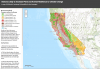 |
Web based | conservation planning | California | The Nature Conservancy |
This map-viewer from The Nature Conservancy allows you to explore the results of a state-wide vulnerability assessment and see recommended conservation actions based on the study for any area in the state. |
|
AdaptWest Ecoregion Climate Explorer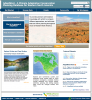 |
Web based | historic and projected climate data | Western North America |
A tool for visualizing current and projected future climate data for North American ecoregions. |
||
CalAdapt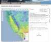 |
Web based | Temperature, Snowpack, Precipitation, Wildfire, Extreme events | California | UC Berkeley Geospatial Innovation Facility |
CalAdapt provides tools to display colorful maps, map animations, and easy-to-read graphs that illustrate how the climate may change based on a variety of different potential social and economic factors. |
|
California Climate and Hydrology Change Graphs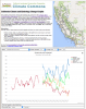 |
Web based | Climate change, hydrology | California | Climate Commons |
This graphing tool presents historical and projected climate and hydrology data values from the California Basin Characterization Model dataset plotted over time for 156 hydrologic basins (HUC-8 basins) that comprise hydrologic California. |
Tutorial Videos |
CalWeedMapper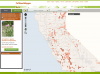 |
Web based | Invasive plants | California | California Invasive Plant Council (Cal-IPC) |
CalWeedMapper uses maps of invasive plant distributions and information about plant spread to inform strategic weed management planning. Contains current distribution maps of 210 invasive plants, maps of suitable range in 2010 and 2050 climate for 79 species. Provides reports of recommended action for a user-defined region. |
Sample Regional Species Map Report |
Climate Adaptation Knowledge Exchange (CAKE)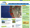 |
Web based | Climate adaptation | World | EcoADapt |
The CAKE website provides searchable collections of four types of climate adaptation information resources: case studies, a document library, a directory of people and organizations, and online tools. Practitioners can join the CAKE Community to participate in discussions and stay abreast of events and topics. |
|
Climate Commons Hosted Datasets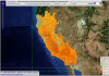 |
Web based | Climate change impacts, hydrology, species distribution, historic and projected climate data | California | Point Blue Conservation Science, CA LCC |
Provides viewing and download of spatial data useful for assessing climate change and its impacts at the watershed scale. Data available here include the Basin Characterization Model, conservation prioritization, and species distribution models. |
3-Minute Tutorial |
Climate Registry for the Assessment of Vulnerability (CRAVe) |
Web based | Species Vulnerability | United States | EcoAdapt |
CRAVe is a searchable database of natural and human resource climate change vulnerability assessments developed for the USGS. Users must create an account and log in, and can add records. |
|
Data Basin |
Web based | conservation planning | World | Conservation Biology Institute |
Data Basin provides online map-making and data-sharing utilities, allowing the user to discover and use shared spatial data & related information, create maps and do certain spatial analyses, use collaborative tools in groups, and publish datasets and maps in organized galleries. |
|
Desert LCC Conservation Planning Atlas |
Web based | Desert ecosystems | Southwest United States | Desert LCC |
The Desert LCC Conservation Planning Atlas is a platform for data discovery, sharing, and collaboration for stakeholders throughout the Desert LCC area. Allows users to search for spatial datasets, visualize LCC-supported projects, and learn more about conservation science and design in the region. |
|
Future San Francisco Bay Tidal Marshes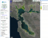 |
Web based | Tidal marshes | San Francisco Bay and Estuary | Point Blue Conservation Science |
Allows the user to select sea-level rise and sedimentation scenarios to examine future tidal marsh habitat change in the San Francisco Bay Estuary over the next 100 years. |
Tutorial video |
Hazus-Multi-Hazard (MH) |
Desktop GIS | Economic loss, Preparedness, Natural Hazards | United States |
A powerful risk assessment methodology for analyzing potential losses from floods, hurricane winds, coastal surge and earthquakes. |
||
Modeling Bird Distribution Responses to Climate Change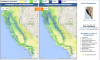 |
Web based | birds | California | Point Blue Conservation Science |
Probabilities of occurrence of California Birds Species of Special Concern modeled using present day and future projected vegetation and climate variables. |
|
NatureServe's Climate Change Vulnerability Index |
Spreadsheet | Species Vulnerability | United States | NatureServe |
Allows the user to apply information about a species’ natural history, distribution and landscape circumstances to predict whether it will likely suffer a range contraction, population reductions, or both during the coming years. |
Guidelines |
Our Coast Our Future (OCOF)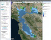 |
Web based | Sea level rise, Extreme events, Flooding | Coastal Central California, San Francisco Bay and Estuary | Point Blue Conservation Science |
A decision support tool developed with the user community to support understanding of infrastructure and ecosystem vulnerabilities from sea level rise and storm hazards. The model incorporates factors such as water levels, wave heights, flooding, and erosion. |
Tutorial videos |
ScienceBase |
Web based | Spatial data | United States | USGS |
ScienceBase is a scientific data and information management platform. Geared primarily toward spatial data management by federal government agencies and partnerships, the system offers cataloging, hosting, visualization, web services, and documentation tools as well as the ability to create a community to share information. |
|
Simple Population Model Tool for Four Marsh Bird Species |
Spreadsheet | birds, Tidal marshes | San Francisco Bay and Estuary | Point Blue Conservation Science |
This spreadsheet tool was created to enable managers to assess known and potential risks, and to evaluate the efficacy of proposed management actions to counteract threats to long-term viability of four key San Francisco Bay marsh species. |
|
The Climate Commons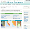 |
Web based | Climate change | California | The California Landscape Conservation Cooperative |
The Climate Commons offers searchable catalogs containing documents, datasets, and web resources pertaining to climate change science applicable to conservation in California. The website also has articles interpreting climate science for the manager, a tool comparison section, and serves as the data repository for research projects funded by the CA LCC. |
|
The Land Use Portfolio Model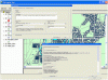 |
Desktop GIS | Public Safety, Natural Hazards |
A tool for modeling, mapping, and communicating risk designed to help public agencies and communities understand and reduce their vulnerability to, and risk of, natural hazards. |