
The Basin Characterization Model (BCM) Dataset
About the Dataset
The Basin Characterization Model (BCM) dataset provides historical and projected climate and hydrology data at a 270 meter resolution, which is relevant for watershed-scale evaluation and planning. These data have formed the basis for multiple research projects and vulnerability assessments applying climate change projections to conservation decision-making, providing a common base-layer and set of assumptions across these projects.
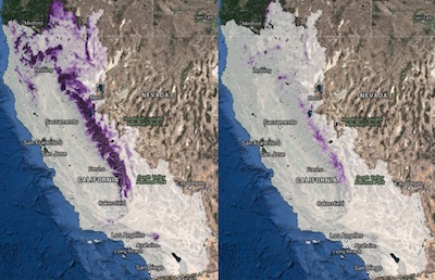 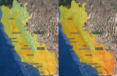 A sample comparison of historical and modeled future data. Top: April snowpack. Bottom: Max temperature. |
How to get BCM data:
More Information
|
Comparison of BCM Dataset Versions
| Year Released | Geographic Extent | Variables | Time Periods | Models | Points of Access |
| 2011 | Hydrologic California |
precipitation max temp min temp climatic water deficit potential ET actual ET recharge runoff excess water snowfall snowmelt snowpack soil water storage sublimation |
Historic: 1910-1939 1940-1969 1970-1999 Projected: 2010-2039 2040-2069 2070-2099 |
4 CMIP-3 GCM+SRES combos | |
| 2014 | Hydrologic California |
precipitation max temp min temp climatic water deficit potential ET actual ET recharge runoff April 1 snowpack |
Historic: 1921-1950 1951-1980 1981-2010 Projected: 2010-2039 2040-2069 2070-2099 |
7 CMIP-3 GCM+SRES combos and 11 CMIP-5 GCM+RCP combos |
|
| Nevada/Great Basin | same as 2014 CA dataset | same as 2014 CA dataset | 6 futures plus historic |
What's new in the 2014 dataset:
The original BCM for California was based on a southwest US product (Flint and Flint 2007), and refined for the California Energy Commission PIER working group effort. This model relied on 4-km spatial resolution climate data from PRISM, the original southwest US maps of national soils (STATSGO), and a regional snow and potential evapotranspiration calibration (see Flint and Flint 2007). This model had a suite of basins that were used for calibration to calculate basin discharge and compare it to measured streamflow to develop statistics across the state and evaluate relative uncertainties in model performance. Future climate projections used in the hydrologic response to future climates for this version of the model were 4 projections (2 models, GFDL and PCM, and 2 emissions scenarios from CMIP3, A2 and B1) that were bias-corrected to the 4-km PRISM historical climate and applied to the BCM.
The revised modeling for the CA-BCM described in Flint et al. (2013) includes the updated 800-m spatial resolution climate data from PRISM, the county level soils data (SSURGO) for the entire state, and more rigorous snow and PET calibrations for California. This dataset included updates to all the basin calibrations as well. The future climate projections included the original 4 projections that were revised with bias-corrections to the 800-m historical PRISM climate, plus an additional 3 projections from the CMIP3 dataset (IPCC 4th Assessment Report) and 11 projections from the CMIP5 datasets (IPCC 5th Assessment Report). These projections included a range of emissions scenarios and representative concentration pathways. All projections were processed by the BCM to provide hydrologic response to 18 future climates.
Use of datasets and limitations:
The BCM is developed to calculate relatively unimpaired hydrologic conditions and the available datasets do not consider surface impoundments, urbanization, land surface disturbances such as wildfire or deforestation, diversions or other impairments. These datasets can be used to evaluate strategic choices regarding land use, evaluation of relative landscape resiliency to climate change with implications for wildfire, forest health, pests, species distributions and biodiversity, and invasive species. They can be used to evaluate potential changes to water availability and extremes, including flooding, peak flows, erosion, drought, environmental flows and fisheries and recharge zones. The limitations to the appropriate spatial application can be quite small if the underlying input properties are accurate because the energy load calculations are based on the resolution of the digital elevation model, in this case, 270 m. The variables most closely associated with energy loads (PET, AET, CWD) could potentially be applied at the hillslope scale, given the resolution of SSURGO soils data for most locations. However, it is recommended that most hydrologic applications be considered at no less than the size of planning watersheds (Natural Resources Conservation Service’s California Interagency
Watershed Mapping Committee; CalWater 1999).
The estimate of spatially distributed runoff does not equal basin discharge as measured at a streamgage without post-processing to determine the components of runoff and recharge that contribute to stream channel gains and losses, which must be done using some measured data for a given basin. The resultant parameters corresponding to the gains and losses generally reflect climatic conditions and geologic setting, but at the scale of California have not been determined to a degree that allows for the direct extrapolation of basin discharge to all ungaged basins.
The spatial distribution of runoff and recharge, however, provides relative differences over the region and can indicate the differences in sensitivity of basins to changes in climate. The estimates of changes in soil moisture and CWD do not rely on interpretation of bedrock permeability, and uncertainties correspond more closely with those of the mapped soil properties and climate data. Because the BCM model outputs are calculated on a grid-cell basis, results can be summarized across landscapes using summary units of any size of interest such as watersheds, ecoregions, or political boundaries. The ability to spatially project hydrologic model outputs permits the cross-comparison of these landscape delineations, with mapped outputs of interest to various fields of research.
Examples of Basin Characterization Model Applications:
Examples of projects using the BCM Dataset include plant species distribution modeling, studies of shifts in small mammal ranges, and fire frequency modeling. Here are some specific examples:
- Vulnerability Assessment and Adaptation Strategies for Focal Resources of the Sierra Nevada
- Climate Change/Land Use Change Scenarios for Habitat Threat Assessments on California Rangelands
- Maximizing evolutionary potential under climate change in southern California protected areas.
- Downscaling future climate projections to the watershed scale: a North San Francisco Bay Estuary case study . See also this Video interview with Dr. Lisa Micheli explaining the research and results.
- Application of the basin characterization model to estimate in‐place recharge and runoff potential in the Basin and Range carbonate‐rock aquifer system, White Pine County, Nevada, and adjacent areas in Nevada and Utah
- Decision support for climate change adaptation and fire management strategies for at risk species in southern California
- Simulation of Climate Change in San Francisco Bay Basins, California: Case Studies in the Russian River Valley and Santa Cruz Mountains
- Targeting climate diversity in conservation planning to build resilience to climate change.
More Resources relevant to the BCM
On the Climate Commons:
- Applying the BCM dataset to conservation planning and management issues
- Choosing and using climate-change scenarios for ecological-impact assessments and conservation decisions
- Why So Many Climate Models?
- About raster resolutions
- Literature authored by Lorraine and Alan Flint
External Resources