
Overview of Projected Change in the California Central Valley
You may also be interested in this more detailed information and bibliography.

| Summary of Observed and Projected Trends for California's Central Valley: | |
|
|
Future Projections for the Central Valley:
TemperatureThe average mean annual temperature in the Sacramento–San Joaquin basin is projected to increase by 5 to 6°F during this century, though with substantial variability in warming in the Central Valley. In addition, the duration of extreme warm temperatures is expected to increase from 2 months (July and August) to four months (June through September). (Bay Delta Conservation Plan). During the next few decades, scenarios project average temperature to rise between 1 and 2.3°F with models producing similar results due to being based on greenhouse gases already emitted. Model results begin to diverge at mid-century and by the end of the century the temperature increases projected in the higher emissions scenario (A2) are approximately twice as high as those projected in the lower emissions scenario (B1). (CalAdapt) |
|
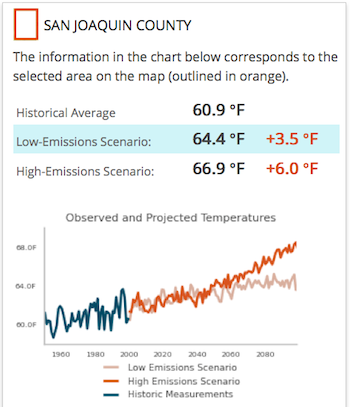 Above: Graph from CalAdapt using CMIP3 models |
 |
Extreme HeatModels project a significant rise in the number, intensity, and length of heat waves. In the graph at right from CalAdapt, every year in the last quarter of the century is projected to have one or more 5-day periods with temperatures exceeding today's threshold considered extreme for the region. |
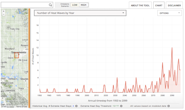 Above: A chart from CalAdapt showing a count of 5 day heat waves projected for 1950-2099. |
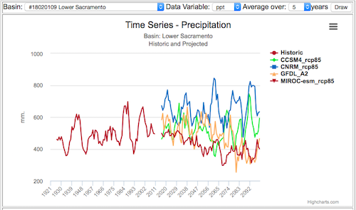 Historical and modeled future precipitation for the Lower Sacramento Hydrologic Basin using a 5-year running average. California Climate and Hydrology Graphs, Climate Commons 2015. Data source: CA Basin Characterization Model. |
PrecipitationProjections of future precipitation are uncertain; models vary widely and different sub-regions can exhibit different patterns. While it is difficult to discern strong trends from the full range of climate projections, one recent analysis indicated a drying trend in California during the 21st century (Cayan et al. 2009). According to this analysis, some areas in northern California may experience higher annual rainfall amounts and potentially larger storm events, but California as a whole, particularly southern California, will be 15 to 35% drier by 2100 (Cayan et al. 2009). Models with both more and less overall precipitation for California indicate an increase in drying as measured in climatic water deficit (Micheli et. al., 2012), so there is high certainty that there will be an increase in summer dryness even in years of higher than average precipitation. |
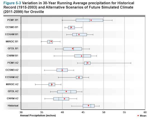 Above: Precipitation projections from the California Water Plan |
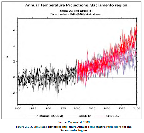
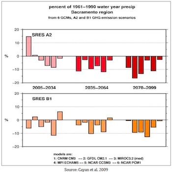 Above: Projected change in Sacramento region precipitation, using five GCMs with A2 and B1 scenarios from the Bay Delta Conservation Plan. |
DroughtDroughts are projected to become more frequent and more severe with climate change. Diffenbaugh et al. (2015) and Mann and Glieck (2015) show that the increasing co-occurrence of dry years with warm years raises the risk of drought despite limited evidence of a trend in precipitation itself, highlighting the critical role of elevated temperatures in altering water availability and increasing overall drought intensity and impact. Read more about Drought and Climate Change. |
|
|
Yearly average climatic water deficit, a measure of potential water demand by plants that is unmet by soil moisture, is projected to increase steadily. Beyond the year 2030 the 10-year average consistently exceeds the historical extreme. Projections of streamflow in the latter half of the 21st century yield “critically dry” water years 8% more often than in 1951–2000 in the Sacramento Valley and 32% more often in the San Joaquin Valley (Null et al., 2013). |
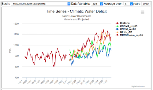 Above: Yearly Climatic Water Deficit for the Lower Sacramento Basin showing four models, using a 5-year running average (California Climate and Hydrology Graphs, Climate Commons 2015). Data source: CA Basin Characterization Model. |
FloodsAn analysis of climate change projections for California indicates that although the average intensity of atmospheric river (AR) events does not increase, there may occur more years with many AR events and occasional events that are much stronger than historical ones. Moreover, the length of the season over which AR events may occur is predicted to increase. These changes to the patterns of AR events may result in more frequent and more severe floods in California (Dettinger 2011). Models suggest that flooding may become more intense on the western slopes of the Sierra Nevada mountains, which feed Central Valley streams and rivers. Regardless of precipitation projections all models project that by end of century, and discharges from the Northern Sierra Nevada with 50-year return periods increase by 30–90% compared to historical values. Corresponding flood flows from the Southern Sierra increase by 50–100%. (Das et al., 2013) |
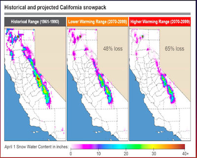 Above: Projected April 1 snow water equivalent 2070-2099, from Pierce and Cayan 2013) in the California Water Plan (2013). |
Sierra Nevada Snowpack, Snowmelt, and Runoff
The timing of springtime snowmelt in the Sierra Nevada is controlled by air temperature and has been earlier in recent years. Regardless of the amount of precipitation, less is likely to fall as snow, and snowpack will not maintain the water supply as long into the dry season as at present. |
|
The timing of peak monthly runoff is projected to continue to shift earlier in the year, further constraining water management by reducing the ability to refill reservoirs after the flood season has passed.
Dam releases provide a cold water supply that will be increasingly needed to counter the effects of climate change on native fishes. |
 Monthly average runoff of Sacramento River System, from the California Water Plan (2013) |
Agriculture and Urban Land Use and Water DemandFuture water demand is affected by a number of growth and land use factors, such as population growth, planting decisions by farmers, and size and type of urban landscapes. For the California Water Plan, the UPlan model was used to estimate a year 2050 urban footprint under the scenarios of alternative population growth and development density. Models project an increase in human population with associated increases in urban water demand and reductions in irrigated agricultural acreage and agricultural water demand. |
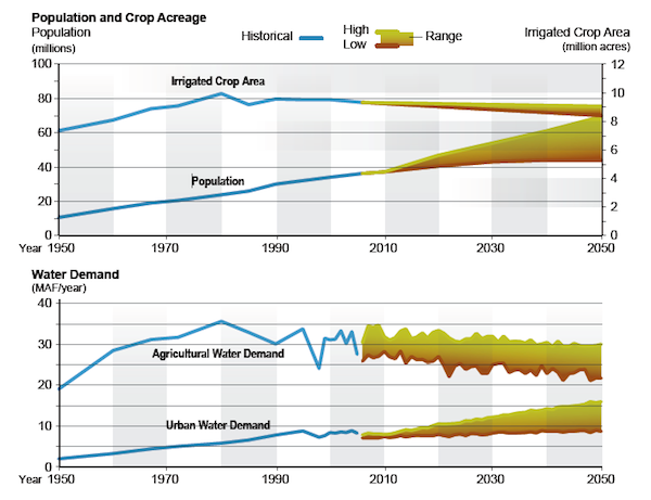 Above: Crop Acreage and Population, Agricultural and Urban Water Demand Projections from the California Water Plan |
7/2017